Enable Accurate Environmental Perception with 3D Point Cloud Annotation
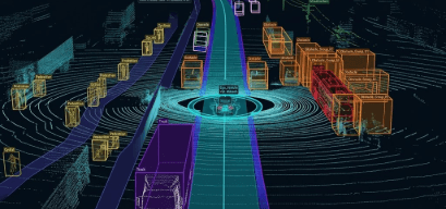
DataMeta provides 3D LiDAR data labeling services that transform raw point cloud data into structured datasets for autonomous systems and advanced AI applications. Our annotation specialists accurately label objects, surfaces, and environmental elements to improve spatial awareness, object recognition, and real-time scene interpretation. High-quality LiDAR annotations help organizations develop reliable perception models for autonomous vehicles, robotics, smart infrastructure, and geospatial intelligence solutions.
Fields We Serve
High-precision LiDAR annotation services that transform point cloud data into structured datasets for autonomous systems, mapping, and spatial intelligence applications.
Autonomous Vehicles
Label vehicles, pedestrians, cyclists, road infrastructure, and obstacles within LiDAR point clouds to support self-driving technologies.
Robotics & Automation
Create detailed 3D annotations that help robots understand environments, navigate safely, and interact with surrounding objects.
Smart Cities & Infrastructure
Annotate urban environments, buildings, roadways, and public assets to support city planning and intelligent infrastructure management.
Geospatial Mapping
Process LiDAR datasets for terrain modeling, land surveying, environmental monitoring, and large-scale mapping projects.
Construction & Engineering
Identify structures, equipment, and site features within point cloud data to improve project planning and asset management.
Industrial & Warehouse Operations
Enable spatial awareness systems for inventory tracking, facility monitoring, autonomous equipment, and logistics optimization.
Why 3D LiDAR Data Labeling Matters
Enable Accurate Spatial Understanding
Annotated point cloud data helps AI systems recognize object positions, distances, and relationships within complex 3D environments.
Improve Real-Time Navigation
High-quality LiDAR labels support autonomous systems in detecting obstacles and making safer navigation decisions.
Enhance Environmental Mapping
Structured point cloud annotations provide detailed representations of real-world environments for mapping and analysis.
Accelerate 3D AI Development
Well-labeled LiDAR datasets create reliable training data for machine learning models used in robotics, mobility, and spatial intelligence.
Ready to Transform Your Business?
Partner with us to leverage cutting-edge AI and technology solutions. Let's turn your vision into reality.