Project Overview
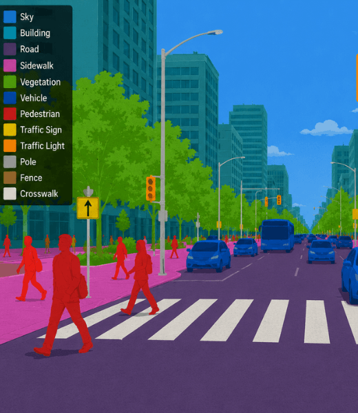
A smart mobility solutions provider collaborated with Avyaycore to develop a large-scale semantic segmentation dataset from CCTV traffic footage. The project focused on accurately labeling every pixel within road scenes, including vehicles, pedestrians, roads, sidewalks, lane markings, traffic signs, vegetation, buildings, and public infrastructure. The resulting dataset enables AI models to better interpret complex urban environments, supporting intelligent traffic management, congestion analysis, and next-generation smart city applications.
Project Objective
The primary objective was to create a highly accurate semantic segmentation dataset that enables computer vision models to understand urban traffic environments at the pixel level. The dataset was designed to improve road scene interpretation, traffic flow analysis, infrastructure monitoring, and intelligent transportation systems powered by AI.
Business Need / Problem Statement
The client required a high-quality segmentation dataset capable of supporting advanced traffic analytics and smart city AI applications. Existing datasets lacked sufficient annotation precision, scene diversity, and infrastructure coverage. Avyaycore established a scalable semantic segmentation workflow that delivered consistent, high-resolution annotations suitable for modern computer vision and deep learning models.
Key Highlights
Pixel-Level Scene Segmentation
Precisely annotated roads, vehicles, pedestrians, sidewalks, lane markings, buildings, vegetation, and traffic infrastructure.
Complex Urban Environment Coverage
Captured and labeled traffic scenes from busy intersections, highways, residential streets, and commercial districts.
Smart Infrastructure Annotation
Segmented traffic signals, streetlights, road barriers, crosswalks, and road signs for AI-powered infrastructure analysis.
Multi-Condition Dataset
Included daytime, nighttime, rainy, foggy, and varying weather conditions to improve AI model robustness.
Quality-Controlled Annotation
Applied multi-stage expert validation to ensure annotation consistency and pixel-level accuracy.
AI-Ready Computer Vision Dataset
Prepared datasets optimized for semantic segmentation, scene understanding, and intelligent traffic analytics.
Challenges We Overcame
Result
The completed urban scene segmentation dataset significantly enhanced the client's computer vision models by improving road scene understanding, traffic object recognition, and infrastructure analysis. The AI-ready dataset established a reliable foundation for intelligent transportation systems, smart city monitoring, autonomous mobility research, and real-time traffic analytics.
Data Collection
CCTV Cameras, Roadside Surveillance & Smart City Sensors
Annotation
Semantic Segmentation & Pixel-Level Image Labeling
Quality Assurance
Expert Review & Automated Validation
Output Format
COCO, Cityscapes, PNG Masks & JSON
Ready to Transform Your Business?
Partner with us to leverage cutting-edge AI and technology solutions. Let's turn your vision into reality.